
North East England August 2003
We are planning a week trip around the northern part of Scotland, so we thought that we should take a long weekend trip. This would test how Seth would react to travelling and sleeping in a strange and exotic place (ok, not that exotic, but it's adds suspense to the upcoming pictures). We didn't want to go too far away, so we chose a wee trip to the North East corner of England, including Durham, Darlington, Stockton and a couple of places inbetween.
England - Darlington - We left late Friday night, map in hand to our first destination - Darlington. We arrived at the hotel at around midnight, so it was quite hard to get a feel for what the place was like. When we awoke, I stuck my head out the window, and this was the best view. Ok, to be perfectly honest, we also had a view of the parking lot, but I didn't take a picture of that.
Seth always seems to wake up around 6:00am, but usually has a nap or two (or three) through the day. This is him just before we were to venture to the rest of the county.

We decided to take a trip to the Fountain Abbey (don't ask, you'll find out later). This shot is kinda like gorillas in the mist, but with a Abbey instead. Since the abby is probably over a thousand years old, it has been slowly sinking into the ground. One day, only the visitor centre will be left.

Help Kim, Seth and I to will the Abbey to rise... Let's all channel our collective energy - think "Rise", think "Rise"... If we all channel our energy together, the abbey will rise before us... If Uri Geller can do it, we all can!

This was one of the dorms for the monks and clerics. As you can see now, it is mainly used for picnic parties.

Wow! We all pulled together, and were able to lift the abby out of the mud. Give yourself a big pat on the back. This is our first glimpse of the antique abbey.

Here is a map of the pictures above and below. We will be starting at Car Park A, going to the abbey, going along the canal to the water garden, following the canal to the lake, looking across to the octagon tower, and going cross country past St. Mary's Church and returning to Car Park A.

Here's a close up of the steeple.

Here's the rest of the building, looking back towards the dorms.

Even though the buildings haven't been used in hundreds of years, they actually still look structurally sound. Add a roof, some gyprock, some mud and paint, and you have a great summer place by the coast.

A panoramic shot of the end of the abbey.

This is looking up the tower, from the inside.

From inside the abbey, here is the tower at the end of the abbey.

Kim and Seth are just entering the abbey from one of the entrances at the end of the abbey.

Kim and Seth are getting closer...

Looking down the great walls of the old abbey, at what must have been a glorious site.

These stairs lead to the dungeon, where if you were kept if you didn't get your prayers correct.

A panoramic view of the front of the abbey (which would be from the other side of where we arrived from)

Doing a 180, this is the view with the abby behind me, and the canal to the right.

Leaving the abbey, walking following the creek.

To keep the water levels high in the creek, they create steps in the creek.

Most people are familiar with seeing the "s-hawks" of the city, so these might be a little foreign to you - these are pheasants. And, there were tonnes of them. All over the place. You couldn't catch them all if you had all day. So, we caught just enough for supper. How many can you find (answer on next pic).

Just incase you couldn't find the last 3 from the picture above, here's an easy one. Or, is there more than one???

This one would be really hard to spot if it wasn't for his red on his neck.

The male is quite easy to see, but the female is quite a bit harder to see, even though she is right in the open.

The creek from the abby feeds into a larger pond, and then flows just below the pictures and into the widened canal on the left. Unfortunately, when we were there, they were busy diging these up, and making them better. I am not sure how they could make something better that has been around for 500 years or so, but they are going to try.

The round circles are where they have some of the fountains. Unfortunately, due to all the construction, the fountains weren't working.
Also, remember I said there was tonnes of pheasants, well, if you look on the dam to the lower left, you will notice that the pheasants are using the dried up dam as a bridge to get to the other side.

Here's a better picture of the pheasants highway with the canal. At the end of the canal, is a little step bridge and a lake beyond. Remember this for later as there are more pictures coming up.

Walking parallel to the canal, this is looking onto the fountains.

There's this Greek mini-parathon on the grounds, but, as you can tell, it's on the other side of the canal. As we didn't have our swimming kit with us, we decided to give that side of the grounds a pass.

This is looking back towards the way we came. The fountains and mini-parathon would be on the left, and the pheasant highway at the end of this canal.

Pearched high on the hill, is this octagon viewing tower. From here you could view the fountains, canals, and the lake. Quite a nice venu. If you go back 5 or so pictures, you can see the tower in the trees.

For the adventerous of us, you could walk across the canal using this little step bridge. It would be quite a feat if you were legless on abby wine.

After wading through the water (cause I fell off the bridge), this is looking up along the canal. A little sludgier than the other canals, but, hey, that's nature's cleaning devices.

There is a little waterfall at the end of the canal, which leads into this beautiful lake. (next two pictures)


After trekking cross country for a good while, St. Mary's Church rose out of the long grass, and presented herself to us.

A little further up the hill...

And, a last goodbye to St. Mary's and to the Fountain Abbey.

England - Durham - One of our side trips was to Durham. According to the guide book, it had an interesting cathedral and castle. So, we thought, why not. It's pretty close to where we are staying, so off we went. After we returned, our next door neighbour told us of an interesting carving. Someone had carved the last supper into the woods. When you walk around, you can see the different people, but it's only when you sit where Jesus would have sat do you see the entire carving. I guess it's like that old quote of not seeing the forest for the trees.
I thought this wee picture was brilliant. With a normal house, if you want an extension, you'd just add it to the back. Now, what happens when you live over the river? You have no backyard. So, the next best thing is to add your back room over, well, nothing, and your living room gets a nice extension over, well, nothing really. I would have thought they would have made the extensions a little less visable by at least making the roof's match.

Here is the castle, looking at it from the street. Quite a few castles (like this one) were built on a man made hill. Durham castle is lucky, as it is also on a natural hill, so they didn't have to build much of a hill.

Here is the castle taken from one of the bridges, closer to the city centre.

Although this river is quite wide, it is a very sleepy river with hardly any current. At the top of the river (just before the bridge) is a little dam, which is probably only 4 feet high, just to keep the water level in each step high.
The castle is on the top left and the cathedral is on top center.
Hold the right arrow key down to see the entire picture.

This is a Church of England Cathedral, and was built 1093.
Hold the right arrow key down to see the entire picture.

Here is a closeup of the steeples of the cathedral.

And, a closer look from the main entrance.

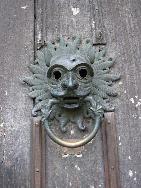
This is "The Sanctuary Knocker" from the Cathedral door. In the Middle Ages the Cathedral provided a refuge for fugitives. Anyone who had committed a serious offence could claim sanctuary by knocking on this door. The fugitives were given thirty-seven days to organise their affairs. They had to decide either to stand trial or to leave the country by the nearest port. This knocker is a replica. The original is in the St. Cuthbert Exhibition in the Cathedral precincts.
This would / should be the front of the cathedral, however, it is stuck near the end of these pictures because it was the last place that we visited. Around the UK, they are doing a lot of restoration work, and to get to this part of the cathedral, we actually kinda stumbled upon it. We had to walk past quite a bit of construction, and walked past fences, and quite literally stumbled across it. Now, you are probably wondering how you would just stumble across the front of a 1000 year old building, especially when I've already taken a dozen pictures of it, but, that's my story. Go there if you don't believe me!

The cathedral is on the left, and the castle entrance is on the right. These are several buildings that are now part of the university campus. Kim and Seth are directly infront. You can tell that is Seth, as just in his wee hand is a bottle of Bucky. Also, they had this wide open space, with, as we've all guessed, a "Keep Off The Grass" sign. Silly when it was such a lovely day.

These statues and crests were on the rightmost building from the picture above.

If you go to the right from the buildings in the last picture, you will come to this lovely courtyard.
Here's a question - how do you take a wide angle picture of a round courtyard? Well, for this one I am going to have to get you to use your imagination. This was taken from an the entrance into the courtyard. Unfortunately, since it was during the summer recess, we weren't allowed to go any further.
Hold the right arrow key down to see the entire picture.

I took this picture from one of the bridges. The cathedral is on the top left, castle on the top right, and the rest of the city, sprawled across the middle. They had a nice path along the river, however, on the bottom right they have been working on a mall, and you are totally diverted from the river bank. This was probably done by the Gap.
The other interesting thing about this picture, is that the sky blends perfectly in with the webapge. So, do I just have extra white space on my website, or is the sky really that color?

This was taken from one the bridges, with the main city centre directly ahead of me, the mall and parkade just showing on the left, and the castle high on the hill.
Notice how the sky has turned quite a bit bluer. Weird weather.

After walking from the bridge in the above pic, you enter the city centre. This street was semi-pedistrianized, allowing probably 1 car every minute to drive down the street.

Following the road from the picture above to the right, it would open up onto this square.

Here's a wider angle of the above picture. Notice the major traffic jam? It is really weird when you do get a car along these ped streets, as you forget what to do (and then get ran over).

This is a statue of Charles William Vane Stewart (close up from the picture in the square). He was the 3rd Marouis of Londonderry, the 1st Earl Vane and Baron Stewart of Stewarts Court KGGCB, Lord Lieutenant County of Durham, Founder of Seaham Harbour and General in the army. He lived from 1778 to 1854. He probably died of a tired hand from writing all his titles. I read where if a horse is on all four legs, then the person died normally (well, you know what I mean), if the horse is on 3 legs (1 raised) then the person died from an injury from a battle, and if the horse is on two legs (2 raised) then the person died in battle. I am not sure if that is the rule in this case, because Chuck would have been in his 70's which is a little old for hand to hand combat.

The next two pictures are of the city, looking down from the castle.


When we started walking along the river, we didn't have this map. So we started from the carpark, across the river, then across the river (two different bridges), up to the cathedral, wondered along past the university, and then ended up in the city centre totally in the opposite direction that we had started, unaware of the route that we had taken. Now (a month later) looking at this map, it makes total sense.

The next seven pictures are of the winding, sleepy river.
This is looking east, almost at the northern tip of the river. The university is at the left of the river, and the bridge was built for and by the university. You might have noticed that there are quite a few pictures of the castle, town and cathedral, but none of the university. There's a reason for this - the university is, well, ugly. Picture lego. Paint it grey. Make it square. Add several more lumps of grey lego. Add some windows. There, you now have a picture of the university campus. Actually, that's not 100% true. The cathedral and castle is now owned by the university, but that was built way before the university, so we can't give them credit for that.

This is looking 180 degrees from the above picture, with the university behind me. The bridge infront is the one in the picture of the castle, city, mall, parking lot. There were a lot of bridges in this city.
If you follow the bridge to the right (just in the trees) was that weird house that was had all of the additions above the river.

This is looking down river, with the castle just popping out of the trees. The thin line in the river is actually a dam, to keep the water level high.

Looking down the same bridge, the cathedral has just popped out of the trees. The castle is still hiding in the trees down the river.

Same bridge - different angle. Here we have a couple of rowers turning their boat around (cause they can't go that way - remember the dam?)

And, awwwaay they go down the river (or, actually up the river, cause the current is going the other way but you already knew that...)
This is looking 180 degrees from the above picture.

All gone - no more rowers. Quick, aren't they?

While we were wondering along the river, we found this gem that had been left by the Romans. Notice how small the door is? This is from around 90AD, and is still in beautiful shape. Probably because it is hidden from the city centre.

England - Yorkshire Countryside - During our driving from town to town, rather than take the rather bland M motorways, we decided to take some of the A roads. Now, looking back on it, I'm thinking that A stands for Adventerous, as when we started on the roads, they were nice and straight roads, then they started getting twisty, then they were nothing more than a 1 lane road with the occassional pullover spot to allow on-comming traffic to pass you. I don't think I've ever used my breaks or reverse more on any stretch of road! On the plus side, the next 5 pictures are quite beautiful. Makes you think of "All Creatures Great And Small", doesn't it? Queue the music now, and picture some old guy in a tweed cap driving over the hills, in search of poorly coos...


England - Stockton - Our original reason for going to this part of England, is because around Easter, we had purchased a night's stay at the Swan Hotel chain, and the coupon's expiry date was Sep 1. This meant that we had to quickly get out of the city (and country as well) to use this coupon or else it would have been a waste. We called the Swan Hotel to see if they had any free nights on Friday, and they said yes. We said we had a coupon, and then they said no. Humph. So, we were eventually to use the coupon for a Sunday night, and stay in Darlington for the Friday and Saturday nights.
Here is a shot from our hotel window around 8:30 Monday morning. This was quite a quiet part of town, as only busses and taxi's were allowed down this section of the street. What I found really interesting is that even at 8:30, the town is dead.

This picture is looking 90 degrees directly left of the first picture. At the end of the street was a bar, but even on the weekend, this place was quiet quiet. I am not sure if this is just not a party town, or if maybe all the good pubs are on the other side of town or what. We were expecting it to be a lot busier.

This picture is looking 90 degrees directly right of the first picture. The mast in the near distance is the tall ship on the river (more below). Quite a nice sleepy town.

Here is Seth on the hotel bed, acting cute. In this picture, he is just over 2 months old. This is an action shot, with him kicking is foot while he sleeps. Oor wee wayne.

After a wonder through the city, we decided to walk along the waterfront. They have an old naval boat which I believe is used by the sea cadets for practicing on. The two bridges around the vessle are too low, so I am not sure how they are going to get the boat out. I guess let the air out of the tires, and just slide it under the bridge.

Here is the "Teesquay Millennium Footbridge" which was opened on 20th December 2000. I think they kinda missed the boat on it being open for the Millennium (ok, I know that the millennium was 2001 but everybody celebrated it as 2000). It would appear as if the bridge can piviot and open like the Millennium bridge in Newcastle, but, no. It is infact welded in place.

Walking a little closer, we notice that there is a boating school practicing between the bridges. There were about a dozen little boats, all zig zagging around the river. It was really good that they were on a very calm river as they were only learning, and weren't that good. They all had to wear helmets - I didn't think boating was a contact sport.

Here is a little better picture of the sailing class. The instructor was in the red powerboat, and he was going from boat to boat barking instructions.

Here is a better picture of the tall ship. This is taken from the millennium bridge.

Here is a picture of the tall ship and the boating class looking towards the ocean.

England - Blythe - Blythe (sorry, didn't name it) is one of those wee coastal towns, that you just putter through. The one interesting point about about Blythe is although it isn't very large, it is quite beautiful, and because they want tourists, they make the roads confusing so that when you leave the city, you will get lost and have to drive around for a bit to exit the city.
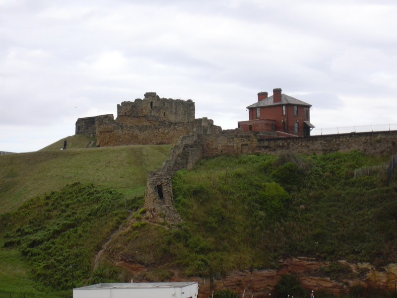
When we first entered the city, you are greeted by this old castle, and the shore below. I illegally parked the car, jumped out, and took a handful of pictures. There were parking meters all around, but fortunately this isn't Glasgow, so there were no parking enforcers, so parking was kinda free. To view this picture in it's entirity, hold the right arrow key down.

Here is a little more of the beach and a bit of the seawall.

Just up the hill from the beach, were these houses. What a great view - the castle, the beach, the waves. Wow. Must be wonderful to live there. And, since none of the flats have balcony's, you can just go out your front steps onto the boardwalk, and grab a bench. Easy peezie lemon squeezie.

You could call this picture a drive by shooting. Unfortunately there wasn't any parking at the top of the hill, so, cameras drawn, this was taken out of a very slow car (with annonyed people behind us). Next time, we'll stop the car, hold up traffic, and get a less blury picture.

This is the castle from the other side. We parked here for about 15 minutes, and enjoyed the view, donuts and ice cream. To view this picture in it's entirity, hold the right arrow key down.

Here is a little closer picture of the ruins and it's wall.
If you follow the seawall from the above pictures, it will lead you out to the breakwater and lighthouse.

And, following the seawall along the coast, would talk you to the rest of the town.

England - Hartlepool - Hartlepool is just one of those places that we stopped, not because of any main attraction, but because it was time for Seth to wake up. We bundled him up in his wee blue blanket and we ran (well, I did, remember Seth still can't walk) from the car park high upon the cliffs, down to the chilly beach below.
This is walking down from the carpark on the top of the cliffs, looking toward the town.

This is coming down from the cliffs, looking away from the city.

And we've actually made it down the hill, and are looking down the beautiful beach. This will be a great place when the summer sun would be out. Fortunately it is only a couple hour drive from home, if we can rememeber exactly which roads we took to get there.

Ok, this might not be the best postcard picture for this beach, but it goes on for miles and miles. Such a shame that it wasn't a bit nicer day. But, we were on holiday, so we didn't care, and Seth didn't complain.

Looking towards the town from the bottom of the hill.

Here's a picture of the beach greeting us to come for a swim.

Although you can't picture how chilly the ocean actually is, the lack of people on this summer day should give a little hint.

Seth is enjoying the cool summer air. Actually, he was really sleepy, and even though it was quite cold, he fell asleep a couple of times.

This is Seth's first act of graffiti - just a quick "Seth Waz Here" in the sand, and we were off just incase the polis waz to nip us.

England - New Biggin By The Sea - This is the town of New Biggin By The Sea. You can tell it's by the sea, cause, hey, there it is! This part of England has beautiful beaches. It was just a shame that it wasn't a warmer, nicer day. To view this picture in it's entirity, hold the right arrow key down.

Needing a break, we found this wee man made lake along the road close to New Biggin By The Sea (no, really - that's the town's name). By the manacuring of this lake and the mini-cafe / tourist centre, I am guessing that this lake is no more than 5 years old. It was a beautiful park, and as you can see by the number of swans, they seemed to like it as well. There also seemed to be quite a few walkers around, as paths zig-zagged through this setting, going into the hills beyond. The one problem with this setting, is that it is quite close to an air base, so there were several low fly bys from the jetting community. We just hid in the trees at the side of the lake.

The white little puffalumps on the shore are actually swans playing and just enjoying the beautiful day.

England - Holy Island - Holy Island was just off the coast a couple of miles. The interesting thing about the island is during low tides, it was a pennunsilia, and during high tides, it was an island. Before you drive on the old, salt encrusted road, there is a tide table, with warning signs saying not to cross during these times. Since we had just bought this car, and it was running fine, I thought I'd better take notice of these postings. If it was a rental car, that would be a different story - remember the poor car we took to Alaska? I've never seen a car cry before. Anyways, we had about an hour before the tide was to come in, so we took a chance and crossed the narrow causeway.
I believe Holy Island received it's name because of this monastary. The monastary is perched upon a rocky hill, making it not only have a great view of the island and mainland, but also giving it a defensive position as well. Doesn't this look like the castle from the "Black Island" by Herge?


The actual monistary doesn't look real, does it? This is actually using my zoom on max, plus using the digital zoom, so it might look a little grainier than normal, but this is the genuine article. I'm thinking by living up there on the rocks, that they didn't want too many visitors.

England - Bamburgh - One interesting part about the UK is that you can be driving around, thinking about nothing, and out pops a castle. It wasn't on any map, or in any of the travel books or anything. So, I hit the binders hard, throwing Seth into the front seat, and I jumped out, and grabbed this picture.

The next four pictures were taken from the car park, about 90 degrees from the left of the first picture.

Here is the guard wall...

The guard wall and part of the moat. The sharks have left, but the crocidiles still live on the grassy noles, eating the occassional poodle that falls into the mud pits.

And, here is the front of the castle.

This is part of the view that the castle would have had in it's hay day. Isn't that a horrible pun?
